Map of the Cosmos
Overview
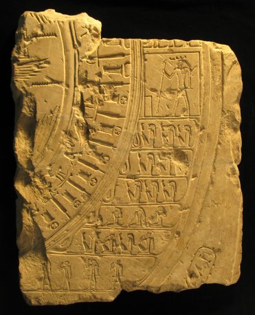
Map of the Cosmos [ edit ]
This stone slab, part of a larger monument of uncertain provenance, is one of the earliest depictions of the world as a spherical framework; a complete version of a similar circular map appears on a Thirtieth Dynasty sarcophagus at the Metropolitan Museum of Art (MMA 14.7.1B), and from this parallel one may restore elements missing or damaged on the Yale fragment. In keeping with their orientation towards the south—right and west were synonymous for the Egyptians as were left and east—the Yale fragment depicts the northwest portion of the Egyptian world. The Egyptian theologians who designed the map were also able to transform the linear geography of the Nile Valley into a circular form. In religious and cult-topographical terms, theirs was a heliocentric cosmos; the center of the map, of which only a small portion remains, contains the tips of two pairs of wings, which belong to the sun god Re as a winged sun disk. Surrounding the divine world is Egypt, represented by the standards of its 42 administrative districts, often called after their later Greek designation, nomes. The Yale fragment contains the standards of six nomes of the northwest Delta alternating with the Per-nu shrine of Lower Egypt; the three uppermost standards are among the northernmost nomes of Upper Egypt and alternate with the Per-wer shrine of the south
The next portion of the ancient map, the ring beyond the borders of Egypt, depicts foreign countries, in this case the Libyan tribes who dwelt west of the Delta. Standing enshrined in a rectangular hieroglyph that “temple,” is Ha, tutelary deity of the Western Desert. Below Ha are members of the Libyan tribes who populated the eastern portion of the Sahara Desert, and the line separating the Libyans from Egypt is actually composed of loops of rope binding them to the districts of the Nile Valley.
Beyond the Libyan desert and separated by a double line is the final region of the Egyptian cosmos: the primeval, chaotic waters from which all life originated. In the hieroglyphic signs on the map, this outer region is called “the cool waters of Horus;” Horus often appears as a falcon or falcon-headed deity and was worshipped as a sky god closely associated with kingship. The waters of Horus are separated from Egypt and foreign territories, but the boundary between order and chaos is not impermeable. The Nile itself ultimately flowed from these waters, and the ancient Egyptians believed that only the proper religious rituals, which helped to maintain the course of the sun and the divine world, would prevent the chaotic waters from spilling into Egypt.
Date
664-332 BCE
Period
Late Period Egypt
Dimensions
H. 57 cm; W. 43 cm
Museum
Yale Map Collection
Accession Number
*61
J.J. Clère, “Fragments d’une Nouvelle Représentation Égyptienne du Monde,” MDAIK 16 (1958): 30-46.
G. D. Scott, Ancient Egyptian Art at Yale (New Haven, 1986), pp. 154-155.